{gallery}articles/may/diy4{/gallery}
Click to enlarge…
Oh jeez, now we’re getting a tiny bit Scared.
OUR MAGIC DAY: MAY 10, 2009
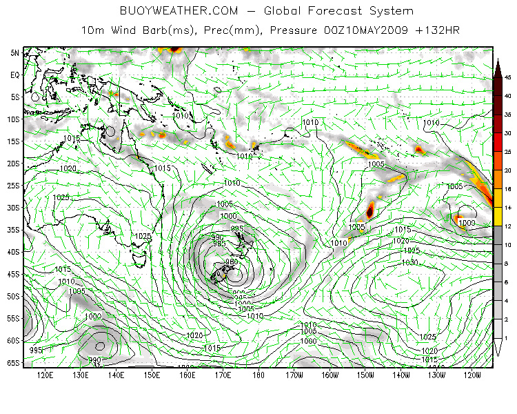
The forecast continues to firm in the direction of Mega Bombshell.
Today’s prog surface chart puts our storm right on top of New Zealand, with that massive south-east fetch now tilted straight at the NSW coastline. And unlike so many storms along the Australian east coast, this one is far enough away that if it all comes true, the coast will see something rare and horrendous: a pure groundswell.
See one feature of east coasts (and this goes for almost every east coast in the world btw) is that they face away from the general flow of weather systems around the world.
If you look to the south of our big arse island continent for instance, you’ll see a procession of big low pressure systems marching west to east pretty much all the time, blasting westerly gales across the Southern Ocean. The same sorta thing happens in the northern part of the globe – big storms charging west to east across the North Pacific and Atlantic Oceans, and freezing the crap out of places like Alaska and Siberia.
So most of the world’s great swells are formed by westerly winds, something the crew in Hawaii, WA, western Vicco and Tasmania know all too well.
East coasts, if they’re lucky (like we are here in Oz) get some good hits from the fringes of these big winds when occasionally they turn southerly. Plus there’s swell off oceanic tradewinds, and windswell from strong coastal weather and seabreezes etc. Yeah there’s some big days. But most big swells on east coasts are pretty wild and crazy affairs, because the storms that create ‘em are usually really close to the coastline. These close-in storms, cyclones and exploding low pressure cells, smash the coast with everything at once – wind, rain, and swell that’s all piled up together in a semi shapeless mass. Putting it simply, you’re right in the middle of the fetch.
Swells get organised once the fetch that makes ‘em is at a distance. All the choppy nonsense is quickly filtered out and you’re left with the real thing. You can tell swells that have distant fetches by the interval between individual swell waves – the longer the gap between waves in a set, the further off the fetch and the stronger the winds involved.
Such “long-period” groundswells hardly ever hit the Aussie east coast with much grunt. But this one looks a different kettle of fish. It’s far enough away to allow a fair bit of chop filtering, but the winds – if they follow this forecast – will be way up there in the 50-knot range … and covering a LOT of water in the process.
Here’s a crazy extra bit to the forecast – the computers who drew this map are suggesting that the swell created by it will hit the mid-NSW coastline on Monday morning, May 11, at 23 feet with a 15-second-plus interval. If that happens, it’ll be the biggest pure groundswell to hit this coast in a generation. It’ll be in the Eddie Aikau league.
Keep watching, folks.
Nick Carroll


